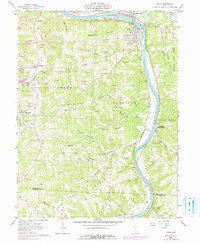
1961 Map of Philo
USGS Topo · Published 1990About this map
Muskingum River navigation and industrial resource extraction define this portion of the valley in the early 1960s. The twin settlements of Duncan Falls and Philo anchor the northern reaches, where the Baltimore and Ohio railroad tracks follow the river's path, connecting riverside industry to broader markets. The landscape is deeply carved by numerous runs and hollows, including Salt Creek and Brush Creek, which separate high-elevation features like Fatler Ridge and Butterbean Ridge.
Find a feature on this map
55 named features on this map. Tap any name to fly to it.
Don’t see what you’re looking for? This feature index may not catch every label — zoom into the map to look around manually.
Map Details
Editions of this 1961 Philo Map
4 editions found
Other maps of this area

1910 · Philo
USGS Topo · 1:62,500

1910 · Zanesville
USGS Topo · 1:62,500

1910 · Mc Connelsville
USGS Topo · 1:62,500

1911 · New Lexington
USGS Topo · 1:62,500

1947 · Columbus
USGS Topo · 1:250,000

1949 · Clarksburg
USGS Topo · 1:250,000

1956 · Clarksburg
USGS Topo · 1:250,000

1961 · Columbus
USGS Topo · 1:250,000

1961 · Clarksburg
USGS Topo · 1:250,000

1961 · Mc Connelsville
USGS Topo · 1:24,000