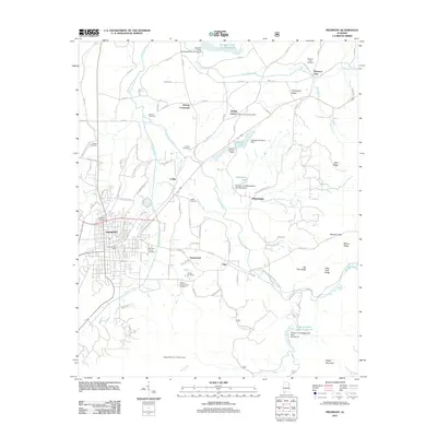
2011 Map of Piedmont
USGS Topo · Published 2011About this map
Piedmont and its surrounding agricultural valleys are the central focus of this 2011 survey, showing a landscape defined by the drainage of Terrapin Creek and its many tributaries. The area maintains a series of small, established rural communities such as McFrey Crossroads, Ladiga, and Vigo, many of which grew around early rail and road intersections. Water management is a significant feature of this terrain, evidenced by the numerous engineered reservoirs including Terrapin Creek Lake Number 8 and La Garde Lake. For genealogists, the map is particularly useful for locating family burial grounds, such as Goshen Cemetery, Farmer Cemetery, and Hanks Cemetery. The southeastern portion of the map transitions into the high ridges of Oakey Mountain and Wilson Ridge, where the Dugger Mountain Lookout Tower stands as a prominent landmark overlooking the valley floor near the South Fork Terrapin Creek.
Find a feature on this map
100 named features on this map. Tap any name to fly to it.
Don’t see what you’re looking for? This feature index may not catch every label — zoom into the map to look around manually.
Map Details
Editions of this 2011 Piedmont Map
This is the sole edition of this map. No revisions or reprints were ever made.
Other maps of this area

1886 · Rome
USGS Topo · 1:125,000

1889 · Tallapoosa
USGS Topo · 1:125,000

1892 · Tallapoosa
USGS Topo · 1:125,000

1893 · Fort Payne
USGS Topo · 1:125,000

1897 · Tallapoosa
USGS Topo · 1:125,000

1898 · Rome
USGS Topo · 1:125,000

1898 · Fort Payne
USGS Topo · 1:125,000

1899 · Rome
USGS Topo · 1:125,000

1900 · Fort Payne
USGS Topo · 1:125,000

1900 · Anniston
USGS Topo · 1:125,000