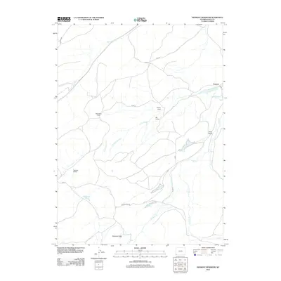
2012 Map of Piedmont Reservoir
USGS Topo · Published 2012About this map
Piedmont sits at the center of a complex network of high-desert water management and grazing land in southwestern Wyoming. This 2012 survey illustrates how the landscape around Moslander Ridge is defined by a series of small, catch-basin reservoirs such as Piedmont Reservoir, Little Piedmont Reservoir, and Guild Reservoir. These water features, alongside seasonal drainages like Muddy Cr and Silver Springs Cr, highlight the essential infrastructure required for ranching and resource management in Uinta County. Significant terrain landmarks such as Horseshoe Bend and Twomile Hollow provide orientation across the sagebrush-covered draws. The local road network, including the Piedmont Aspen Rd and Altamont Rd, traces the movement between these isolated watering holes and the historic settlement site, reflecting the region's long-standing reliance on its limited water sources.
Find a feature on this map
28 named features on this map. Tap any name to fly to it.
Don’t see what you’re looking for? This feature index may not catch every label — zoom into the map to look around manually.
Map Details
Editions of this 2012 Piedmont Reservoir Map
This is the sole edition of this map. No revisions or reprints were ever made.
Other maps of this area

1954 · Ogden
USGS Topo · 1:250,000

1958 · Ogden
USGS Topo · 1:250,000

1960 · Ogden
USGS Topo · 1:250,000

1965 · Ragan
USGS Topo · 1:24,000

1965 · Leroy
USGS Topo · 1:24,000

1965 · Sulphur Creek Reservoir
USGS Topo · 1:24,000
1965 · Hague Creek
USGS Topo · 1:24,000

1965 · Guild Hollow
USGS Topo · 1:24,000
1965 · Pine Knoll
USGS Topo · 1:24,000
1965 · Moslander Reservoir
USGS Topo · 1:24,000