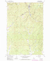
1966 Map of Pierce
USGS Topo · Published 1984About this map
Pierce and its surrounding timberlands are documented here in the mid-1960s, showing the town's position at the edge of the Clearwater National Forest. The map captures a unique blend of historical and industrial landmarks, from the Chinese Hanging Trees Historical Marker near Hildebrand to the active timber operations at Cardiff Mill and Brown Creek Mill. The drainage of Orofino Creek dominates the northern terrain, while the residential expansion into Judge Town and the outlying community at Peterson Corners reflect the area's mid-century footprint. Resource management and recreation are evident through the Moore Pierce Work Center and the Brown Creek Moto Cross Area, set against a landscape defined by significant elevations like Gold Hill and the Pierce Divide.
Find a feature on this map
41 named features on this map. Tap any name to fly to it.
Don’t see what you’re looking for? This feature index may not catch every label — zoom into the map to look around manually.
Map Details
Editions of this 1966 Pierce Map
2 editions found
Other maps of this area

1923 · Washington Creek
USGS Topo · 1:125,000

1924 · Weippe
USGS Topo · 1:125,000

1938 · Headquarters
USGS Topo · 1:48,000

1944 · Headquarters
USGS Topo · 1:62,500

1956 · Hamilton
USGS Topo · 1:250,000

1959 · Hamilton
USGS Topo · 1:250,000

1960 · Hamilton
USGS Topo · 1:250,000

1964 · Hamilton
USGS Topo · 1:250,000

1965 · French Mountain
USGS Topo · 1:24,000

1966 · Pierce
USGS Topo · 1:24,000