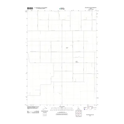
2010 Map of Pillar Butte SE
USGS Topo · Published 2010About this map
Pleasant Valley and the surrounding high plains of Bingham County define this landscape, characterized by a grid of rural roads and agricultural life in the early 21st century. The map reveals a highly structured network of thoroughfares, such as N Pleasant Valley Rd and S Pleasant Valley Rd, which divide the terrain into large parcels. One of the few non-agricultural sites noted is the Bredding Ranch Landing Area, indicating the importance of private aviation for transport and ranch management in this part of Idaho. This survey reflects the persistence of the homesteading layout, where family names like Schroeder, Brugemeister, and Schatz are preserved in the local geography. The western edge of the quadrangle is defined by Lava Beds Rd, marking the transition into the unique basalt-heavy geology of the Snake River Plain.
Find a feature on this map
26 named features on this map. Tap any name to fly to it.
Don’t see what you’re looking for? This feature index may not catch every label — zoom into the map to look around manually.
Map Details
Editions of this 2010 Pillar Butte SE Map
This is the sole edition of this map. No revisions or reprints were ever made.
Other maps of this area

1934 · American Falls
USGS Topo · 1:62,500

1934 · Rockland
USGS Topo · 1:62,500

1936 · American Falls
USGS Topo · 1:62,500

1937 · Rockland
USGS Topo · 1:62,500

1954 · Pocatello
USGS Topo · 1:250,000

1958 · Pocatello
USGS Topo · 1:250,000

1959 · Yale
USGS Topo · 1:62,500
1971 · American Falls SW
USGS Topo · 1:24,000

1971 · American Falls NW
USGS Topo · 1:24,000
1971 · Neeley
USGS Topo · 1:24,000