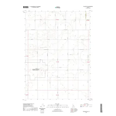
2020 Map of Pillar Butte SE
USGS Topo · Published 2020About this map
Wapi Flow Craters of the Moon National Preserve dominates the southwestern corner of this Idaho landscape, marking a stark geological boundary where volcanic terrain meets the agricultural grid of Pleasant Valley. This area in Bingham County illustrates the transition from the basaltic flows of the Snake River Plain to the developed farmsteads and rural infrastructure of the early 21st century. The map reveals a dense network of locally named thoroughfares such as Burgemeister Rd, Quigley Rd, and Schritter Rd, which reflect the area's settled history and land ownership patterns. The alignment of Lava Beds Rd and Wapi Rd highlights how human movement was dictated by the edge of the lava fields, providing a clear visual record of how the landscape's natural features shaped the development of its transportation network.
Find a feature on this map
37 named features on this map. Tap any name to fly to it.
Don’t see what you’re looking for? This feature index may not catch every label — zoom into the map to look around manually.
Map Details
Editions of this 2020 Pillar Butte SE Map
This is the sole edition of this map. No revisions or reprints were ever made.
Other maps of this area

1934 · American Falls
USGS Topo · 1:62,500

1934 · Rockland
USGS Topo · 1:62,500

1936 · American Falls
USGS Topo · 1:62,500

1937 · Rockland
USGS Topo · 1:62,500

1954 · Pocatello
USGS Topo · 1:250,000

1958 · Pocatello
USGS Topo · 1:250,000

1959 · Yale
USGS Topo · 1:62,500
1971 · American Falls SW
USGS Topo · 1:24,000

1971 · American Falls NW
USGS Topo · 1:24,000
1971 · Neeley
USGS Topo · 1:24,000