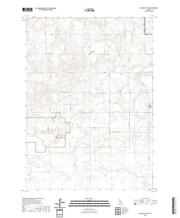
2023 Map of Pillar Butte SE
USGS Topo · Published 2023About this map
Pleasant Valley stretches across the center of this Power County landscape, defined by a network of rural routes that reflect a long history of local landholdings. In the western reaches, the jagged edge of the Wapi Flow marks the boundary of the Craters of the Moon National Preserve, where volcanic geology meets the agricultural plains. The human history of the valley is anchored by the Evangelical Lutheran Cem near Quigley Rd, a quiet marker of the community's early settlement. The road network itself carries the names of local families, including Winters Rd, Schritter Rd, and Burgemeister Rd, tracing the distribution of homesteads and farms across the high desert terrain of southern Idaho. The division between Power Co and Bingham Co is also noted along the eastern margin.
Find a feature on this map
38 named features on this map. Tap any name to fly to it.
Don’t see what you’re looking for? This feature index may not catch every label — zoom into the map to look around manually.
Map Details
Editions of this 2023 Pillar Butte SE Map
This is the sole edition of this map. No revisions or reprints were ever made.
Other maps of this area

1934 · American Falls
USGS Topo · 1:62,500

1934 · Rockland
USGS Topo · 1:62,500

1936 · American Falls
USGS Topo · 1:62,500

1937 · Rockland
USGS Topo · 1:62,500

1954 · Pocatello
USGS Topo · 1:250,000

1958 · Pocatello
USGS Topo · 1:250,000

1959 · Yale
USGS Topo · 1:62,500
1971 · American Falls SW
USGS Topo · 1:24,000

1971 · American Falls NW
USGS Topo · 1:24,000
1971 · Neeley
USGS Topo · 1:24,000