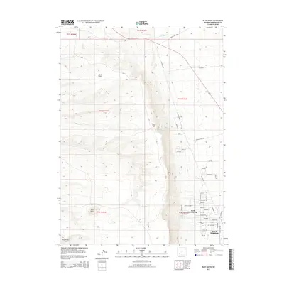
2015 Map of Pilot Butte
USGS Topo · Published 2015About this map
White Mountain dominates the central topography of this Wyoming landscape, acting as a natural divider between the expanding residential areas to the east and the high desert terrain to the west. On the eastern slopes, the development of North Rock Springs and the northern edge of Rock Springs is evident, characterized by a structured street grid including Washakie Drive and Gannet Drive. The western half of the map reveals a more isolated environment defined by drainage systems like Skunk Canyon and Greasewood Canyon. This contrast highlights the physical constraints and corridors of the region's modern growth. Prominent landmarks such as Pilot Butte provide significant navigational markers above the surrounding flats. The area is intersected by historical travel routes including Yellowstone Road and the Chilton Cutoff Road, which navigate the elevation changes dictated by Scott Canyon and the surrounding high ridges.
Find a feature on this map
48 named features on this map. Tap any name to fly to it.
Don’t see what you’re looking for? This feature index may not catch every label — zoom into the map to look around manually.
Map Details
Editions of this 2015 Pilot Butte Map
This is the sole edition of this map. No revisions or reprints were ever made.
Other maps of this area

1908 · Rock Springs
USGS Topo · 1:62,500

1910 · Rock Springs
USGS Topo · 1:62,500

1954 · Rock Springs
USGS Topo · 1:250,000

1958 · Rock Springs
USGS Topo · 1:250,000

1958 · Boars Tusk
USGS Topo · 1:62,500

1961 · Scott Spring
USGS Topo · 1:24,000

1961 · Pilot Butte
USGS Topo · 1:24,000

1961 · Kanda
USGS Topo · 1:24,000

1961 · Green River
USGS Topo · 1:24,000

1962 · Rock Springs
USGS Topo · 1:250,000