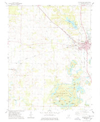
1974 Map of Pinckneyville
USGS Topo · Published 1978About this map
The Perry County seat of Pinckneyville serves as the hub of this mid-1970s landscape, where the Illinois Central Gulf and Missouri Pacific railroads converge near the Fairgrounds. The map reveals an area defined by its extraction history, prominently featuring several Strip Mined Areas and associated Tailings south of town. These industrial zones contrast with the development of Pyramid State Park, which encompasses a series of recreation-focused water bodies such as Clear Lake, Boulder Lake, and Hook Lake.
Find a feature on this map
60 named features on this map. Tap any name to fly to it.
Don’t see what you’re looking for? This feature index may not catch every label — zoom into the map to look around manually.
Map Details
Editions of this 1974 Pinckneyville Map
2 editions found
Other maps of this area

1910 · Murphysboro
USGS Topo · 1:62,500

1914 · Coulterville
USGS Topo · 1:62,500

1916 · Campbell Hill
USGS Topo · 1:62,500

1917 · Coulterville
USGS Topo · 1:62,500

1918 · Campbell Hill
USGS Topo · 1:62,500

1924 · Pinckneyville
USGS Topo · 1:62,500

1926 · Pinckneyville
USGS Topo · 1:62,500

1938 · Murphysboro
USGS Topo · 1:62,500

1949 · Paducah
USGS Topo · 1:250,000

1950 · Paducah
USGS Topo · 1:250,000