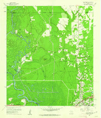
1960 Map of Pine Forest
USGS Topo · Published 1962About this map
The Neches River winds through this coastal Texas landscape, marking the complex boundary between Orange, Jasper, and Jefferson Counties. By the early 1960s, the area reflects a transition from traditional river-and-rail industry to modern suburban and industrial development. The city of Vidor is shown in detail, including the Lucas Sch and local infrastructure, while the North Oil Field and various Oil Wells indicate the continued importance of petroleum extraction. Remnants of earlier eras are visible in the Old Railroad Grade and the Old Texla Mill Road, tracing paths of former commerce. Several community landmarks serve as touchpoints for genealogists, including Williamson Cem and the Colliers Ferry (Site) at Lawson Crossing. The map also captures the managed waterways of the Neches Canal and Wiess Canal, which cut across the low-lying terrain near Huckleberry Ridge.
Find a feature on this map
46 named features on this map. Tap any name to fly to it.
Don’t see what you’re looking for? This feature index may not catch every label — zoom into the map to look around manually.
Map Details
Editions of this 1960 Pine Forest Map
3 editions found
Other maps of this area

1926 · Terry
USGS Topo · 1:24,000

1926 · Lakeview
USGS Topo · 1:24,000

1926 · Vidor
USGS Topo · 1:24,000

1926 · Texla
USGS Topo · 1:24,000

1932 · Beaumont
USGS Topo · 1:62,500

1943 · Terry
USGS Topo · 1:24,000

1943 · Texla
USGS Topo · 1:24,000

1943 · Beaumont East
USGS Topo · 1:24,000

1952 · Lake Charles
USGS Topo · 1:250,000

1954 · Lake Charles
USGS Topo · 1:250,000