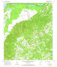
1963 Map of Pine Ridge
USGS Topo · Published 1964About this map
Mississippi River frontage and the rugged breaks of the loess bluffs define this 1963 survey of the borderlands between Mississippi and Louisiana. The terrain shifts from the low alluvial bottomlands of Mercer Island and No 114 Island to the dissected uplands where the Natchez Trace Parkway winds through the eastern portion of the map. This area is characterized by a high density of rural religious and family landmarks, such as Smithland Ch, Second Union Ch, and the Drake-Magruder Cem.
Find a feature on this map
44 named features on this map. Tap any name to fly to it.
Don’t see what you’re looking for? This feature index may not catch every label — zoom into the map to look around manually.
Map Details
Editions of this 1963 Pine Ridge Map
3 editions found
Other maps of this area

1909 · Vidalia
USGS Topo · 1:24,000

1921 · Natchez
USGS Topo · 1:48,000

1922 · Natchez
USGS Topo · 1:62,500

1939 · Lorman
USGS Topo · 1:62,500

1939 · Natchez
USGS Topo · 1:62,500

1939 · Locust Ridge
USGS Topo · 1:62,500

1953 · Natchez
USGS Topo · 1:250,000

1956 · Natchez
USGS Topo · 1:250,000

1958 · St. Joseph
USGS Topo · 1:62,500

1959 · Natchez
USGS Topo · 1:250,000