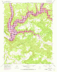
1954 Map of Pine River
USGS Topo · Published 1973About this map
Navajo Reservoir dominates this landscape at the confluence of the San Juan River and the Los Pinos River. This 1954 survey, updated with 1971 revisions, documents the engineering and hydrologic transformation following the construction of Navajo Dam. The map captures a moment when industrial infrastructure and the natural topography of the High Desert converge, showing the expansion of pipelines and numerous gas wells across the high plateaus.
Find a feature on this map
14 named features on this map. Tap any name to fly to it.
Don’t see what you’re looking for? This feature index may not catch every label — zoom into the map to look around manually.
Map Details
Editions of this 1954 Pine River Map
4 editions found
Other maps of this area

1889 · Largo
USGS Topo · 1:250,000

1895 · Largo
USGS Topo · 1:250,000

1954 · Pine River
USGS Topo · 1:24,000
1954 · Burnt Mesa
USGS Topo · 1:24,000

1954 · Rosa
USGS Topo · 1:24,000

1954 · Gomez Ranch
USGS Topo · 1:24,000

1954 · Aztec
USGS Topo · 1:250,000

1958 · Aztec
USGS Topo · 1:250,000

1959 · Gould Pass
USGS Topo · 1:62,500

1959 · Navajo Dam
USGS Topo · 1:62,500