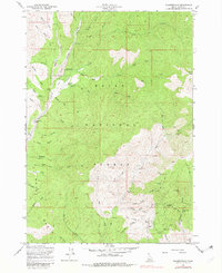
1957 Map of Pioneerville
USGS Topo · Published 1982About this map
Pioneerville sits at the heart of this Idaho survey, which documents the extensive mining activity along the tributaries of Grimes Creek. The map provides a detailed view of the regional extractive economy, showing everything from the Tailings deposits near the main settlement to the Washington Mill and a dense network of claims in the southeast. Hard-rock mining operations are identified across the drainages of Illinois Gulch and Washington Gulch, including the Lucky Boy Mine, Gambrinus Mine, and Mascot Mine. The rugged landscape within the Boise National Forest is further defined by its early transportation network, featuring the Thompson Trail and Lewis Trail winding through high peaks like Wilson Peak. Smaller family operations and landmarks such as Arbaugh Ranch and the local Cemetery offer specific points of interest for those tracing the history of this gold-producing district.
Find a feature on this map
63 named features on this map. Tap any name to fly to it.
Don’t see what you’re looking for? This feature index may not catch every label — zoom into the map to look around manually.
Map Details
Editions of this 1957 Pioneerville Map
4 editions found
Other maps of this area

1894 · Idaho Basin
USGS Topo · 1:125,000

1909 · Garden Valley
USGS Topo · 1:125,000

1955 · Hailey
USGS Topo · 1:250,000

1957 · Placerville
USGS Topo · 1:24,000

1957 · Pioneerville
USGS Topo · 1:24,000

1957 · Warm Springs Point
USGS Topo · 1:24,000

1957 · Idaho City
USGS Topo · 1:24,000

1957 · Challis
USGS Topo · 1:250,000

1959 · Hailey
USGS Topo · 1:250,000

1959 · Garden Valley
USGS Topo · 1:62,500