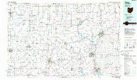
1986 Map of Piqua
USGS Topo · Published 1986About this map
The Indiana Ohio state line bisects this 1986 survey, capturing a vast agricultural landscape anchored by the manufacturing and transit hubs of Piqua and Troy. The region is defined by a dense network of river systems, including the Stillwater River and the Miami River, which supported early industrial growth. The Miami Conservancy District at Lockington indicates the sophisticated flood control infrastructure established in the wake of early 20th-century inundations.
Find a feature on this map
60 named features on this map. Tap any name to fly to it.
Don’t see what you’re looking for? This feature index may not catch every label — zoom into the map to look around manually.
Map Details
Editions of this 1986 Piqua Map
3 editions found
Other maps of this area

1904 · Springfield
USGS Topo · 1:62,500

1904 · Dayton
USGS Topo · 1:62,500

1905 · Brookville
USGS Topo · 1:62,500

1906 · Dayton
USGS Topo · 1:62,500

1906 · Springfield
USGS Topo · 1:62,500

1906 · Lima
USGS Topo · 1:62,500

1908 · St. Henry
USGS Topo · 1:62,500

1909 · Loramie
USGS Topo · 1:62,500

1911 · Berne
USGS Topo · 1:48,000

1911 · Loramie
USGS Topo · 1:62,500