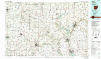
1986 Map of Piqua
USGS Topo · Published 1992About this map
The Great Miami River and its major tributaries, including the Stillwater River and Loramie Creek, anchor the drainage of this western Ohio and eastern Indiana borderland. In the mid-1980s, the region was defined by its robust network of river-valley settlements such as Piqua, Sidney, and Troy, linked by the prominent corridor of Interstate 75. Beyond these industrial and municipal centers, the landscape transitions into a grid of rural townships where smaller communities like Versailles, Bradford, and Covington serve as local hubs. Large-scale water management is evident through the presence of the Loramie Reservoir, Grand Lake-St Marys, and Englewood Reservoir. For those researching family history, the map identifies specific burial grounds including Miami Memorial Park Cem and the Catholic Cem. Conservation areas such as the Darke State Wildlife Area and Mercer Waterfowl Management Area illustrate the 20th-century preservation of natural habitats amidst the intensive agricultural use of the surrounding plains.
Find a feature on this map
125 named features on this map. Tap any name to fly to it.
Don’t see what you’re looking for? This feature index may not catch every label — zoom into the map to look around manually.
Map Details
Editions of this 1986 Piqua Map
3 editions found
Other maps of this area

1904 · Springfield
USGS Topo · 1:62,500

1904 · Dayton
USGS Topo · 1:62,500

1905 · Brookville
USGS Topo · 1:62,500

1906 · Dayton
USGS Topo · 1:62,500

1906 · Springfield
USGS Topo · 1:62,500

1906 · Lima
USGS Topo · 1:62,500

1908 · St. Henry
USGS Topo · 1:62,500

1909 · Loramie
USGS Topo · 1:62,500

1911 · Berne
USGS Topo · 1:48,000

1911 · Loramie
USGS Topo · 1:62,500