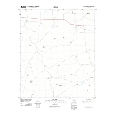
2010 Map of Pitchfork Ranch
USGS Topo · Published 2010About this map
Pitchfork Ranch anchors this landscape in King County, where a complex network of water sources and named landmarks defines the ranching culture of West Texas. The South Wichita River and its tributary Geneva Fork cut through the northern portion of the map, while drainage features like Davidson Canyon and Hanna Draw shape the southern terrain. This 2010 survey highlights a sophisticated infrastructure of named windmills, which serve as vital landmarks for both navigation and livestock management across the vast acreage. From the Corner Windmill in the northeast to the Humble Windmill in the southwest, these features, alongside sites like Flakemoore and Devils Playground Windmill, reflect the generational importance of water management in this arid region. The presence of these specific family and location-named wells offers significant value for researchers tracing land usage and legacy ranch boundaries.
Find a feature on this map
40 named features on this map. Tap any name to fly to it.
Don’t see what you’re looking for? This feature index may not catch every label — zoom into the map to look around manually.
Map Details
Editions of this 2010 Pitchfork Ranch Map
This is the sole edition of this map. No revisions or reprints were ever made.
Other maps of this area

1954 · Lubbock
USGS Topo · 1:250,000

1958 · Pursley House
USGS Topo · 1:24,000

1958 · Southerland Canyon
USGS Topo · 1:24,000

1959 · Gilpin
USGS Topo · 1:24,000

1967 · Guthrie NW
USGS Topo · 1:24,000

1968 · East Afton
USGS Topo · 1:24,000

1968 · Pitchfork Ranch
USGS Topo · 1:24,000

1968 · Croton Camp
USGS Topo · 1:24,000

1968 · East Afton NE
USGS Topo · 1:24,000

1968 · Pitchfork Flats
USGS Topo · 1:24,000