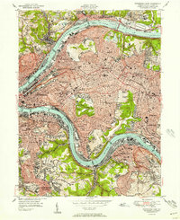
1951 Map of Pittsburgh East
USGS Topo · Published 1951About this map
The confluence of industry and academia defines this mid-century portrait of Pittsburgh's east side, where the Allegheny River and Monongahela River frame a dense urban landscape. Massive institutions like the University of Pittsburgh, featuring the iconic Cathedral of Learning, and the Carnegie Institute of Technology stand adjacent to the expansive greens of Schenley Park. The map captures the city's complex topography, from the riverfront rail lines of the Pennsylvania and Baltimore and Ohio railroads to the residential heights of Squirrel Hill and East Liberty. Large memorial landscapes such as Allegheny Cemetery and Calvary Cemetery are prominent, while the industrial character of the era is evident in the numerous bridges, including the Washington Crossing Br and Rankin Bridge, that connect the city to surrounding boroughs like Etna and Homestead.
Find a feature on this map
101 named features on this map. Tap any name to fly to it.
Don’t see what you’re looking for? This feature index may not catch every label — zoom into the map to look around manually.
Map Details
Editions of this 1951 Pittsburgh East Map
3 editions found

Other maps of this area

1904 · Mc Keesport
USGS Topo · 1:62,500

1904 · Carnegie
USGS Topo · 1:62,500

1906 · Carnegie
USGS Topo · 1:62,500

1906 · Sewickley
USGS Topo · 1:62,500

1907 · Pittsburg
USGS Topo · 1:62,500

1908 · Sewickley
USGS Topo · 1:62,500

1908 · Carnegie
USGS Topo · 1:62,500

1908 · New Kensington
USGS Topo · 1:62,500

1910 · New Kensington
USGS Topo · 1:62,500

1948 · Pittsburgh West
USGS Topo · 1:24,000