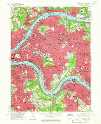
1960 Map of Pittsburgh East
USGS Topo · Published 1966About this map
Pittsburgh is defined by the convergence of its great waterways, with the industrial and academic heart of the city captured in 1960. The landscape is dominated by institutional landmarks like the Cathedral of Learning, the Carnegie Institute of Technology, and the iconic Forbes Field in Oakland. Massive green spaces such as the Allegheny Cemetery and Schenley Park provide a counterpoint to the dense residential districts of Bloomfield and East Liberty. Along the riverbanks, an extensive transport network includes the Monongahela Connecting RR and the Baltimore and Ohio RR, which serviced the heavy industrial zones. A notable landscape feature is the Slag Dump near Nine Mile Run, a stark indicator of the city's mid-century steel production legacy. The map provides a remarkable level of detail for genealogists, showing parish schools like St Hyacinth Sch and local hospitals including Mercy Hospital and VA Hospital.
Find a feature on this map
140 named features on this map. Tap any name to fly to it.
Don’t see what you’re looking for? This feature index may not catch every label — zoom into the map to look around manually.
Map Details
Editions of this 1960 Pittsburgh East Map
4 editions found
Other maps of this area

1904 · Mc Keesport
USGS Topo · 1:62,500

1904 · Carnegie
USGS Topo · 1:62,500

1906 · Carnegie
USGS Topo · 1:62,500

1906 · Sewickley
USGS Topo · 1:62,500

1907 · Pittsburg
USGS Topo · 1:62,500

1908 · Sewickley
USGS Topo · 1:62,500

1908 · Carnegie
USGS Topo · 1:62,500

1908 · New Kensington
USGS Topo · 1:62,500

1910 · New Kensington
USGS Topo · 1:62,500

1948 · Pittsburgh West
USGS Topo · 1:24,000