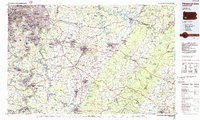
1986 Map of Pittsburgh East
USGS Topo · Published 1986About this map
Industrial corridors and Appalachian ridges define this mid-1980s look at Westmoreland and Allegheny counties. The Monongahela River and Youghiogheny River serve as the lifeblood for steel towns like Clairton, Duquesne, and McKeesport, while the massive Conrail network and the Pennsylvania Turnpike facilitate the movement of goods across the state. The map captures the transition from the dense urban fabric of Pittsburgh and Wilkinsburg to the outlying suburban growth in Monroeville and Greensburg.
Find a feature on this map
399 named features on this map. Tap any name to fly to it.
Don’t see what you’re looking for? This feature index may not catch every label — zoom into the map to look around manually.
Map Details
Editions of this 1986 Pittsburgh East Map
3 editions found
Other maps of this area

1900 · Uniontown
USGS Topo · 1:62,500

1900 · Masontown
USGS Topo · 1:62,500

1900 · Latrobe
USGS Topo · 1:62,500

1901 · Amity
USGS Topo · 1:62,500

1901 · Waynesburg
USGS Topo · 1:62,500

1902 · Latrobe
USGS Topo · 1:62,500

1902 · Indiana
USGS Topo · 1:62,500

1902 · Brownsville
USGS Topo · 1:62,500

1902 · Connellsville
USGS Topo · 1:62,500

1902 · Barnesboro
USGS Topo · 1:62,500