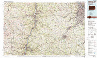
1986 Map of Pittsburgh West
USGS Topo · Published 1989About this map
The Ohio River carves a deep industrial and historical corridor through this 1986 survey, serving as the tri-state artery connecting Pittsburgh, Wheeling, and Steubenville. This map captures a landscape defined by its rugged river valleys and the dense network of coal-and-steel era infrastructure. The expansion of suburban and industrial centers like Weirton and Canonsburg is evident, while the high concentration of named water bodies, including Clendening Lake and Tappan Lake, highlights the importance of water management and recreation in the region. Large-scale public lands such as Raccoon Creek State Park and Hillman State Park stand in contrast to the heavily developed industrial riverfronts. For the researcher, the map preserves the exact alignment of major railroads including the Chessie System and Conrail during a period of significant regional transition, alongside essential local landmarks like the Washington Reservoir.
Find a feature on this map
233 named features on this map. Tap any name to fly to it.
Don’t see what you’re looking for? This feature index may not catch every label — zoom into the map to look around manually.
Map Details
Editions of this 1986 Pittsburgh West Map
3 editions found
Other maps of this area

1900 · Masontown
USGS Topo · 1:62,500

1901 · Cadiz
USGS Topo · 1:62,500

1901 · Amity
USGS Topo · 1:62,500

1901 · Waynesburg
USGS Topo · 1:62,500

1901 · Beaver
USGS Topo · 1:62,500

1902 · Wheeling
USGS Topo · 1:62,500

1902 · Brownsville
USGS Topo · 1:62,500

1902 · Scio
USGS Topo · 1:62,500

1903 · Masontown
USGS Topo · 1:62,500

1903 · Cadiz
USGS Topo · 1:62,500