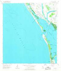
1957 Map of Placida
USGS Topo · Published 1968About this map
Gasparilla Island and its neighboring barrier keys define this mid-century coastal survey of the Florida Gulf coast. The landscape is shaped by the presence of the Seaboard Air Line railroad, which runs the length of the islands toward Boca Grande, indicating the vital role of rail transport in the local economy and development before the modern highway era. The small settlement of Placida serves as a mainland hub, overlooking Placida Harbor where a Ferry Landing once connected these island communities to the mainland.
Find a feature on this map
26 named features on this map. Tap any name to fly to it.
Don’t see what you’re looking for? This feature index may not catch every label — zoom into the map to look around manually.
Map Details
Editions of this 1957 Placida Map
4 editions found
Other maps of this area

1956 · Englewood
USGS Topo · 1:24,000

1956 · Tampa
USGS Topo · 1:250,000

1956 · Charlotte Harbor
USGS Topo · 1:250,000

1957 · Englewood NW
USGS Topo · 1:24,000

1957 · El Jobean
USGS Topo · 1:24,000

1957 · Punta Gorda SW
USGS Topo · 1:24,000

1957 · Placida
USGS Topo · 1:24,000

1958 · Port Boca Grande
USGS Topo · 1:24,000

1958 · Bokeelia
USGS Topo · 1:24,000

1959 · Tampa
USGS Topo · 1:250,000