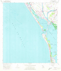
1957 Map of Placida
USGS Topo · Published 1973About this map
Gasparilla Island and its surrounding keys define this coastal area as it appeared before the surge of late-20th-century development. The Seaboard Coast Line railroad runs south along the peninsula to the settlement of Boca Grande, a vital link for the region's early maritime and agricultural economy. Near the mainland at Placida, the tracks cross Coral Creek and Placida Harbor, anchoring a landscape of tidal marshes and intricate waterways including the West Branch and East Branch of the creek.
Find a feature on this map
24 named features on this map. Tap any name to fly to it.
Don’t see what you’re looking for? This feature index may not catch every label — zoom into the map to look around manually.
Map Details
Editions of this 1957 Placida Map
4 editions found
Other maps of this area

1956 · Englewood
USGS Topo · 1:24,000

1956 · Tampa
USGS Topo · 1:250,000

1956 · Charlotte Harbor
USGS Topo · 1:250,000

1957 · Englewood NW
USGS Topo · 1:24,000

1957 · El Jobean
USGS Topo · 1:24,000

1957 · Punta Gorda SW
USGS Topo · 1:24,000

1957 · Placida
USGS Topo · 1:24,000

1958 · Port Boca Grande
USGS Topo · 1:24,000

1958 · Bokeelia
USGS Topo · 1:24,000

1959 · Tampa
USGS Topo · 1:250,000