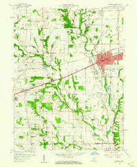
1959 Map of Plainfield
USGS Topo · Published 1960About this map
The Plainfield township and surrounding rural landscape of Hendricks Co and Morgan Co are captured here just as suburban expansion began to shape the corridor west of Indianapolis. The National Road and the Pennsylvania railroad serve as the primary east-west axes, connecting established settlements like Cartersburg and Belleville. A significant institutional presence is noted at the State Boys School south of the main town. The survey documents a transition from purely agricultural land to a community with modern infrastructure, including a sewage disposal plant and a large Gravel Pit. Local history is anchored by numerous small landmarks like the Sugar Grove Ch, St Susanna Sch, and several family burial grounds including Gossett Cem and Spring Hill Cem. The terrain is defined by the drainage systems of White Lick Creek and its many tributaries, such as Abner Creek and McCracken Creek.
Find a feature on this map
30 named features on this map. Tap any name to fly to it.
Don’t see what you’re looking for? This feature index may not catch every label — zoom into the map to look around manually.
Map Details
Editions of this 1959 Plainfield Map
2 editions found
Other maps of this area

1953 · Bridgeport
USGS Topo · 1:24,000

1953 · Clayton
USGS Topo · 1:24,000

1953 · Danville
USGS Topo · 1:24,000

1953 · Brownsburg
USGS Topo · 1:24,000

1953 · Plainfield
USGS Topo · 1:24,000

1953 · Clermont
USGS Topo · 1:24,000

1953 · Indianapolis
USGS Topo · 1:250,000

1955 · Hall
USGS Topo · 1:24,000

1955 · Mooresville West
USGS Topo · 1:24,000

1955 · Mooresville East
USGS Topo · 1:24,000