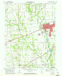
1970 Map of Plainfield
USGS Topo · Published 1976About this map
White Lick Creek carves a winding path through this central Indiana landscape, defining the topography of the Plainfield area as it appeared in the early 1970s. The town of Plainfield serves as a regional hub, showing significant residential and institutional development, including the Indiana Boys School and the Indiana Youth Center. The National Road and the Penn Central railroad corridors facilitate movement across the territory, connecting established settlements like Cartersburg and Belleville.
Find a feature on this map
43 named features on this map. Tap any name to fly to it.
Don’t see what you’re looking for? This feature index may not catch every label — zoom into the map to look around manually.
Map Details
Editions of this 1970 Plainfield Map
3 editions found
Other maps of this area

1953 · Bridgeport
USGS Topo · 1:24,000

1953 · Clayton
USGS Topo · 1:24,000

1953 · Danville
USGS Topo · 1:24,000

1953 · Brownsburg
USGS Topo · 1:24,000

1953 · Plainfield
USGS Topo · 1:24,000

1953 · Clermont
USGS Topo · 1:24,000

1953 · Indianapolis
USGS Topo · 1:250,000

1955 · Hall
USGS Topo · 1:24,000

1955 · Mooresville West
USGS Topo · 1:24,000

1955 · Mooresville East
USGS Topo · 1:24,000