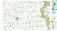
1985 Map of Plainview
USGS Topo · Published 1994About this map
The Caprock Escarpment dominates the eastern edge of this 1985 landscape, creating a sharp geological divide between the High Plains and the rolling breaks to the east. This transition is protected within Caprock Canyons State Park, where deeply incised drainage systems like Pole Canyon Creek and Quitaque Creek have carved into the plateau. The western portion of the sheet is characterized by the systematic grid of the Llano Estacado, centered on Plainview and the adjacent community of Seth Ward.
Find a feature on this map
67 named features on this map. Tap any name to fly to it.
Don’t see what you’re looking for? This feature index may not catch every label — zoom into the map to look around manually.
Map Details
Editions of this 1985 Plainview Map
2 editions found
Other maps of this area

1954 · Lubbock
USGS Topo · 1:250,000

1954 · Plainview
USGS Topo · 1:250,000

1954 · Clovis
USGS Topo · 1:250,000

1954 · Brownfield
USGS Topo · 1:250,000

1957 · Anton
USGS Topo · 1:62,500

1957 · Abernathy
USGS Topo · 1:62,500

1958 · Brownfield
USGS Topo · 1:250,000

1958 · Clovis
USGS Topo · 1:250,000

1958 · Plainview
USGS Topo · 1:250,000

1960 · Indian Peak
USGS Topo · 1:62,500