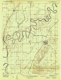
1943 Map of Plainville
USGS Topo · Published 1943About this map
White River meanders sharply through the floodplain of southwest Indiana, defining the shifting boundary between Knox and Daviess counties. This 1940s-era landscape is characterized by an extensive network of drainage infrastructure designed to reclaim the low-lying terrain, including the Smothers Creek Cutoff and several named ditches like Armuth Ditch and Killion Ditch. The town of Plainville serves as a primary hub in the east, while Westphalia sits along the northern edge, both connected by early regional transport lines.
Find a feature on this map
27 named features on this map. Tap any name to fly to it.
Don’t see what you’re looking for? This feature index may not catch every label — zoom into the map to look around manually.
Map Details
Editions of this 1943 Plainville Map
2 editions found
Other maps of this area

1943 · Lyons
USGS Topo · 1:24,000

1943 · Sandborn
USGS Topo · 1:24,000

1943 · Bicknell
USGS Topo · 1:24,000

1943 · Plainville
USGS Topo · 1:24,000

1943 · Epsom
USGS Topo · 1:24,000

1944 · Bucktown
USGS Topo · 1:24,000

1944 · Montgomery
USGS Topo · 1:24,000

1944 · Washington
USGS Topo · 1:24,000

1944 · Wheatland
USGS Topo · 1:24,000

1956 · Vincennes
USGS Topo · 1:250,000