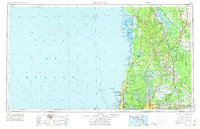
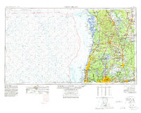
1955 Map of Plant City
USGS Topo · Published 1973About this map
The Gulf of Mexico coastline defines the western edge of this mid-century Florida landscape, where spring-fed rivers and dense wetlands give way to growing inland settlements. In the interior, the Seaboard Coast Line railroad facilitates transport through agricultural hubs like Plant City and Dade City, while the winding Withlacoochee River and Hillsborough River anchor the region's complex hydrology. This era shows the early development of communities such as Spring Hill and New Port Richey before the massive suburban expansion of later decades.
Find a feature on this map
113 named features on this map. Tap any name to fly to it.
Don’t see what you’re looking for? This feature index may not catch every label — zoom into the map to look around manually.
Map Details
Editions of this 1955 Plant City Map
6 editions found

Other maps of this area

1892 · Dunnellon
USGS Topo · 1:62,500

1893 · Panasoffkee
USGS Topo · 1:62,500

1894 · Dunnellon
USGS Topo · 1:62,500

1895 · Tsala Apopka
USGS Topo · 1:62,500

1895 · Panasoffkee
USGS Topo · 1:62,500

1895 · Ocala
USGS Topo · 1:62,500

1921 · Sand Key
USGS Topo · 1:62,500

1921 · Tampa
USGS Topo · 1:62,500

1921 · St Petersburg
USGS Topo · 1:62,500

1943 · Gandy Bridge
USGS Topo · 1:31,680