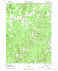
1967 Map of Pleasantville
USGS Topo · Published 1971About this map
The Shamburg Oil Field and surrounding petroleum operations define this corner of Pennsylvania during the late 1960s. Dense clusters of oil and gas wells are mapped across the wooded plateaus, particularly surrounding Pleasantville and the early boom-era site of Pithole City. The landscape is a network of small, rural settlements and crossroads such as Jerusalem Corners, Neilltown, and East Shamburg, many of which grew from the nineteenth-century oil rush.
Find a feature on this map
40 named features on this map. Tap any name to fly to it.
Don’t see what you’re looking for? This feature index may not catch every label — zoom into the map to look around manually.
Map Details
Editions of this 1967 Pleasantville Map
Other maps of this area

1922 · Oil City
USGS Topo · 1:48,000

1922 · Tionesta
USGS Topo · 1:62,500

1924 · Oil City
USGS Topo · 1:62,500

1924 · Tionesta
USGS Topo · 1:62,500

1927 · Tidioute
USGS Topo · 1:48,000

1927 · Titusville
USGS Topo · 1:62,500

1930 · Tidioute
USGS Topo · 1:62,500

1933 · Titusville
USGS Topo · 1:62,500

1943 · Oil City
USGS Topo · 1:62,500

1946 · Tionesta
USGS Topo · 1:62,500
Featured Places
- Pleasantville, PA
- President Township, PA
- Cornplanter Township, PA
- Cattaraugus, Allegheny Township
- Tyrrel Farm Corners, Allegheny Township