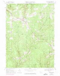
1967 Map of Pleasantville
USGS Topo · Published 1973About this map
Oil fields and scattered pump jacks dominate this landscape in Venango County, where the legacy of Pennsylvania’s petroleum boom is written into the terrain. The map centers on Pleasantville, an incorporated borough surrounded by a network of rural crossroads and family settlements like Tyrrel Farm Corners and Lovell Corners. To the south, the legendary Pithole City appears during a period of transition, showing the remnants of what was once a chaotic boomtown along the banks of Pithole Creek.
Find a feature on this map
46 named features on this map. Tap any name to fly to it.
Don’t see what you’re looking for? This feature index may not catch every label — zoom into the map to look around manually.
Map Details
Editions of this 1967 Pleasantville Map
Other maps of this area

1922 · Oil City
USGS Topo · 1:48,000

1922 · Tionesta
USGS Topo · 1:62,500

1924 · Oil City
USGS Topo · 1:62,500

1924 · Tionesta
USGS Topo · 1:62,500

1927 · Tidioute
USGS Topo · 1:48,000

1927 · Titusville
USGS Topo · 1:62,500

1930 · Tidioute
USGS Topo · 1:62,500

1933 · Titusville
USGS Topo · 1:62,500

1943 · Oil City
USGS Topo · 1:62,500

1946 · Tionesta
USGS Topo · 1:62,500
Featured Places
- Pleasantville, PA
- President Township, PA
- Cornplanter Township, PA
- Cattaraugus, Allegheny Township
- Tyrrel Farm Corners, Allegheny Township