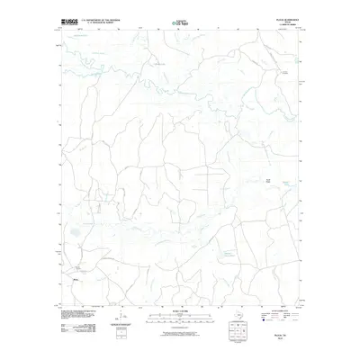
2010 Map of Pluck
USGS Topo · Published 2010About this map
The Neches River winds through this landscape, defining a complex network of waterways including Dollarhide Lake, Albritton Slough, and Lamar Slough. The small settlement of Pluck serves as a local anchor in an area characterized by its intricate drainage patterns, with numerous named branches and creeks like Jones Branch and Steep Hollow Branch feeding into the river system. The presence of Grimes Cemetery and Stryker Cemetery provides valuable points of interest for those researching local family histories and early burials in this part of Polk County.
Find a feature on this map
45 named features on this map. Tap any name to fly to it.
Don’t see what you’re looking for? This feature index may not catch every label — zoom into the map to look around manually.
Map Details
Editions of this 2010 Pluck Map
This is the sole edition of this map. No revisions or reprints were ever made.
Other maps of this area

1927 · Lufkin 4-c
USGS Topo · 1:24,000

1928 · Lufkin 4-d
USGS Topo · 1:24,000

1932 · Manning
USGS Topo · 1:62,500

1953 · Palestine
USGS Topo · 1:250,000

1954 · Beaumont
USGS Topo · 1:250,000

1955 · Camden
USGS Topo · 1:62,500

1955 · New Willard
USGS Topo · 1:62,500

1957 · Beaumont
USGS Topo · 1:250,000

1957 · Palestine
USGS Topo · 1:250,000
1963 · Manning
USGS Topo · 1:24,000