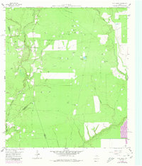
1959 Map of Plum Grove
USGS Topo · Published 1980About this map
Plum Grove and the surrounding Liberty County bottomlands are defined by an intricate network of waterways and ephemeral ponds at the end of the 1950s. The East Fork San Jacinto River winds through the western portion of the map, while Tarkington Bayou and Luce Bayou segment the eastern terrain. The landscape is dotted with numerous named water features, including Russian Pond, Wildcat Pond, and Alligator Pond, illustrating the low-lying, hydrologically active nature of this region.
Find a feature on this map
44 named features on this map. Tap any name to fly to it.
Don’t see what you’re looking for? This feature index may not catch every label — zoom into the map to look around manually.
Map Details
Editions of this 1959 Plum Grove Map

Other maps of this area

1916 · Moonshine Hill
USGS Topo · 1:24,000

1916 · Huffman
USGS Topo · 1:24,000

1920 · Moonshine Hill
USGS Topo · 1:31,680

1920 · Huffman
USGS Topo · 1:31,680

1943 · Liberty
USGS Topo · 1:125,000

1954 · Beaumont
USGS Topo · 1:250,000

1955 · Rayburn
USGS Topo · 1:62,500

1955 · Liberty
USGS Topo · 1:62,500

1957 · Beaumont
USGS Topo · 1:250,000

1958 · Fostoria
USGS Topo · 1:24,000