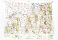
1954 Map of Pocatello
USGS Topo · Published 1976About this map
The American Falls Reservoir and the Snake River anchor this mid-century view of southern Idaho, where massive water management projects transformed the arid high desert into productive agricultural land. The map reveals a landscape defined by the intersection of nature and infrastructure, with the Union Pacific railroad and major corridors like U S 30 and Interstate 15 facilitating regional transit between hubs like Pocatello and Burley. Large swaths of protected wilderness, including the Sawtooth National Forest and Caribou National Forest, flank the agricultural river valleys, while the Minidoka National Wildlife Refuge provides a sanctuary around Lake Walcott. From the volcanic Lava beds to the heights of the Bannock Range, the geography captures the early post-war expansion of small settlements like Chubbuck, Alameda, and Malad City.
Find a feature on this map
45 named features on this map. Tap any name to fly to it.
Don’t see what you’re looking for? This feature index may not catch every label — zoom into the map to look around manually.
Map Details
Editions of this 1954 Pocatello Map
4 editions found

Other maps of this area

1914 · Logan
USGS Topo · 1:125,000

1915 · Preston
USGS Topo · 1:96,000

1916 · Logan
USGS Topo · 1:125,000

1917 · Portneuf
USGS Topo · 1:62,500

1918 · Preston
USGS Topo · 1:125,000

1918 · Paradise Valley
USGS Topo · 1:62,500

1934 · American Falls
USGS Topo · 1:62,500

1934 · Michaud
USGS Topo · 1:62,500

1934 · Rockland
USGS Topo · 1:62,500

1936 · American Falls
USGS Topo · 1:62,500