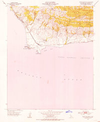
1953 Map of Point Conception
USGS Topo · Published 1954About this map
Point Conception serves as a critical maritime landmark where the California coastline makes its sharpest eastward turn, a geography captured here in the early 1950s. The coastline is dominated by the Coast Guard Reservation and its historic Lighthouse near Indian Head Rock. Inland, the landscape rises into the Santa Ynez Mountains, characterized by complex drainage systems such as Cañada del Cojo and Cañada del Cementerio. The area shows a specialized ranching and transportation economy, with the Southern Pacific railroad hugging the bluffs and small settlements like Concepcion and Cojo Ranch providing localized hubs. Traces of early land divisions appear in the Grant Boundary of the Punta de la Concepcion and Nuestra Senora del Refugio tracts, reflecting the region's Spanish colonial heritage.
Find a feature on this map
34 named features on this map. Tap any name to fly to it.
Don’t see what you’re looking for? This feature index may not catch every label — zoom into the map to look around manually.
Map Details
Editions of this 1953 Point Conception Map
4 editions found
Other maps of this area

1905 · Guadalupe
USGS Topo · 1:125,000

1905 · Lompoc
USGS Topo · 1:125,000

1942 · Point Arguello
USGS Topo · 1:62,500

1942 · Guadalupe
USGS Topo · 1:125,000

1942 · Lompoc
USGS Topo · 1:125,000

1942 · Lompoc
USGS Topo · 1:62,500

1942 · Pt. Conception
USGS Topo · 1:62,500

1943 · Lompoc
USGS Topo · 1:125,000
1947 · Santa Rosa Hills
USGS Topo · 1:24,000
1947 · El Tranquillon
USGS Topo · 1:24,000