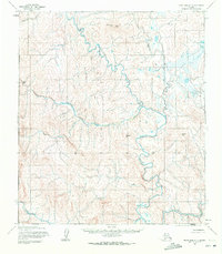
1955 Map of Point Hope C-1
USGS Topo · Published 1972About this map
The Ipewik River winds through this unpopulated expanse of the North Slope, following a path through a landscape defined by isolated elevations and intricate drainage systems. In this mid-century survey, the geography is marked by prominent landmarks such as South Atuk Hill and Amulik Hill, which serve as primary navigational points in a territory with no established roads or trails. Smaller watercourses including Oligarik Creek and Sabrelak Creek feed into the larger river systems, illustrating the complex hydrology of the Arctic coastal plain. The terrain around Tungnak Hill and Tungnak Creek reflects the land-line data predetermined by the Bureau of Land Management, recorded here before further modernization reached this remote corner of Alaska. This document captures the physical character of the land as it was understood during the post-war mapping efforts of the 1950s.
Find a feature on this map
10 named features on this map. Tap any name to fly to it.
Don’t see what you’re looking for? This feature index may not catch every label — zoom into the map to look around manually.
Map Details
Editions of this 1955 Point Hope C-1 Map
2 editions found
Other maps of this area

1951 · De Long Mountains
USGS Topo · 1:250,000

1952 · Point Hope
USGS Topo · 1:250,000

1952 · Point Hope D-1
USGS Topo · 1:63,360

1952 · Point Hope D-2
USGS Topo · 1:63,360

1955 · De Long Mountains
USGS Topo · 1:250,000

1955 · Point Hope
USGS Topo · 1:250,000

1955 · Point Hope C-1
USGS Topo · 1:63,360

1955 · Point Hope B-1
USGS Topo · 1:63,360

1955 · Point Hope C-2
USGS Topo · 1:63,360

1955 · Point Hope B-2
USGS Topo · 1:63,360