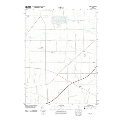
2010 Map of Polk
USGS Topo · Published 2010About this map
Polk serves as a central hub in this Ashland County landscape, defined by a grid of rural roads and the meandering path of Muddy Fork. The 2010 survey highlights a community anchored by tradition, evidenced by the numerous burial grounds such as Hopewell Cemetery, King Cemetery, and Albion Cemetery that dot the townships. Residential development is most concentrated around the waters of Cinnamon Lake, where the Cinnamon Lake Dam regulates the local hydrology. Further south, the map traces the intersection of commerce and transit at the Polk Post Office and the small settlements of Albion and Redhaw. The geography is characterized by several small waterways, including Redhaw Creek and Wolf Run, which feed into the larger drainage system. The distribution of family-named landmarks like Starkey Pond and Burge Cemetery provides essential context for genealogists and local historians tracing the nineteenth-century roots of Jackson Township and its neighbors.
Find a feature on this map
65 named features on this map. Tap any name to fly to it.
Don’t see what you’re looking for? This feature index may not catch every label — zoom into the map to look around manually.
Map Details
Editions of this 2010 Polk Map
This is the sole edition of this map. No revisions or reprints were ever made.
Other maps of this area

1904 · Wellington
USGS Topo · 1:62,500

1906 · Wellington
USGS Topo · 1:62,500

1906 · West Salem
USGS Topo · 1:62,500

1908 · Ashland
USGS Topo · 1:62,500

1908 · West Salem
USGS Topo · 1:62,500

1908 · New London
USGS Topo · 1:62,500

1950 · Marion
USGS Topo · 1:250,000

1956 · Toledo
USGS Topo · 1:250,000

1960 · Nova
USGS Topo · 1:24,000

1961 · Toledo
USGS Topo · 1:250,000