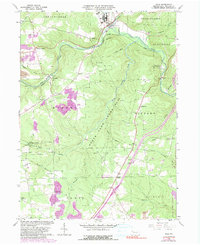
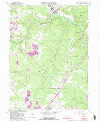
1963 Map of Polk
USGS Topo · Published 1991About this map
Polk lies at the intersection of industry and rural Pennsylvania life, where the Conrail line follows the winding course of Sandy Creek. The landscape is a complex network of resource extraction and conservation, with numerous Oil Wells and a Strip Mine peppered across the hillsides, often in close proximity to the vast State Game Lands No 39 and Kittanning State Forest. The map documents the smaller hamlets and rural crossroads of the early 1960s, such as Raymilton, Henderson Station, and Five Points. Genealogy researchers can find several rural burials and houses of worship, including the Old Sandy Cem, Gadsby Cem, and Mt Pleasant Ch. From the Seneca Hills Bible Conference near the creek to the scattered Spring labels and specialized landmarks like the Landing Strip, the sheet preserves a detailed view of mid-century Venango County.
Find a feature on this map
52 named features on this map. Tap any name to fly to it.
Don’t see what you’re looking for? This feature index may not catch every label — zoom into the map to look around manually.
Map Details
Editions of this 1963 Polk Map
5 editions found
Other maps of this area

1909 · Franklin
USGS Topo · 1:62,500

1910 · Hilliards
USGS Topo · 1:62,500

1911 · Franklin
USGS Topo · 1:62,500

1911 · Stoneboro
USGS Topo · 1:62,500

1912 · Hilliards
USGS Topo · 1:62,500

1913 · Stoneboro
USGS Topo · 1:62,500

1913 · Mercer
USGS Topo · 1:62,500

1939 · Mercer
USGS Topo · 1:62,500

1943 · Mercer
USGS Topo · 1:62,500

1943 · Stoneboro
USGS Topo · 1:62,500