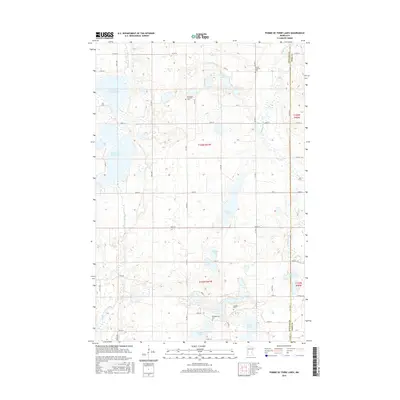
2016 Map of Pomme De Terre Lakes
USGS Topo · Published 2016About this map
Glacial depressions and watercourses define this portion of the Minnesota prairie, where the Pomme de Terre River and the Chippewa River carve through a landscape dotted with numerous lakes. The map reveals a highly structured grid of section lines and township roads such as 150th St and County Road 70, framing a productive agricultural region along the border of Stevens and Pope counties. Notable water bodies including Swan Lake, Baker Lake, and N Pomme de Terre Lake are interspersed with smaller prairie potholes like Erickson Lake and Bjork Lake. Local heritage is anchored by several rural cemeteries, including Aeneas Lutheran Cem and Kirkegaarden Cem, which serve as physical markers of the Scandinavian and German immigrant communities that settled this lake country.
Find a feature on this map
44 named features on this map. Tap any name to fly to it.
Don’t see what you’re looking for? This feature index may not catch every label — zoom into the map to look around manually.
Map Details
Editions of this 2016 Pomme De Terre Lakes Map
This is the sole edition of this map. No revisions or reprints were ever made.
Other maps of this area

1911 · Barrett
USGS Topo · 1:62,500

1912 · Morris
USGS Topo · 1:62,500

1953 · Saint Cloud
USGS Topo · 1:250,000

1957 · Saint Cloud
USGS Topo · 1:250,000

1958 · Saint Cloud
USGS Topo · 1:250,000

1966 · Kensington
USGS Topo · 1:24,000

1968 · Cyrus
USGS Topo · 1:24,000

1968 · Starbuck NW
USGS Topo · 1:24,000
1973 · Patchen Lake
USGS Topo · 1:24,000
1973 · Morris
USGS Topo · 1:24,000