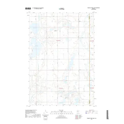
2019 Map of Pomme De Terre Lakes
USGS Topo · Published 2019About this map
Pomme de Terre Lakes define this glaciated landscape in western Minnesota, where the Pomme de Terre River and Chippewa River meander through a region of scattered prairie wetlands and small lakes. The terrain is characterized by a high density of water bodies, including North Pomme de Terre Lake, Swan Lake, and the adjacent North Baker Lake and Baker Lake. For local historians, the placement of rural burial grounds like Emmanuel Lutheran Cem and Seneas Lutheran Cem suggests the locations of early Scandinavian congregations. The county boundary between Stevens and Pope counties runs north-south through the eastern portion of the map, cutting through Otter Lake. The grid of township roads, including Co Hwy 3 and Lake Ave, provides access to these agricultural lands and secluded lakeshores, including Hanson Lake and Moore Lake in the southern sections.
Find a feature on this map
54 named features on this map. Tap any name to fly to it.
Don’t see what you’re looking for? This feature index may not catch every label — zoom into the map to look around manually.
Map Details
Editions of this 2019 Pomme De Terre Lakes Map
This is the sole edition of this map. No revisions or reprints were ever made.
Other maps of this area

1911 · Barrett
USGS Topo · 1:62,500

1912 · Morris
USGS Topo · 1:62,500

1953 · Saint Cloud
USGS Topo · 1:250,000

1957 · Saint Cloud
USGS Topo · 1:250,000

1958 · Saint Cloud
USGS Topo · 1:250,000

1966 · Kensington
USGS Topo · 1:24,000

1968 · Cyrus
USGS Topo · 1:24,000

1968 · Starbuck NW
USGS Topo · 1:24,000
1973 · Patchen Lake
USGS Topo · 1:24,000
1973 · Morris
USGS Topo · 1:24,000