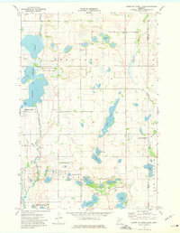
1973 Map of Pomme De Terre Lakes
USGS Topo · Published 1975About this map
The Pomme De Terre Lakes dominate the western portion of this landscape, part of a larger glacial wetland network preserved within the National Waterfowl Production Area. Surveyed in the early 1970s, the terrain represents a classic Minnesota prairie-pothole region where small family-named water bodies like Erickson Lake and Bjork Lake are interspersed with scattered rural institutions. Local history and genealogy are anchored by the Aeneas Ch and its accompanying Aeneas Cem in the northeast, alongside the Scandia Ch and Scandia Cem further south. The boundary between Stevens Co and Pope Co runs vertically through the eastern sections, bisecting the Chippewa River drainage. These rural Townships are marked by a pattern of small Gravel Pits and communal landmarks such as the Townhall, reflecting a landscape dedicated to agriculture and conservation.
Find a feature on this map
28 named features on this map. Tap any name to fly to it.
Don’t see what you’re looking for? This feature index may not catch every label — zoom into the map to look around manually.
Map Details
Editions of this 1973 Pomme De Terre Lakes Map
This is the sole edition of this map. No revisions or reprints were ever made.
Other maps of this area

1911 · Barrett
USGS Topo · 1:62,500

1912 · Morris
USGS Topo · 1:62,500

1953 · Saint Cloud
USGS Topo · 1:250,000

1957 · Saint Cloud
USGS Topo · 1:250,000

1958 · Saint Cloud
USGS Topo · 1:250,000

1966 · Kensington
USGS Topo · 1:24,000

1968 · Cyrus
USGS Topo · 1:24,000

1968 · Starbuck NW
USGS Topo · 1:24,000
1973 · Patchen Lake
USGS Topo · 1:24,000
1973 · Morris
USGS Topo · 1:24,000