
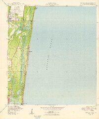
1949 Map of Pompano Beach
USGS Topo · Published 1949About this map
The Florida East Coast railway serves as the spine of this mid-century Broward County landscape, connecting the growing citrus and agricultural hub of Pompano Beach with the burgeoning northern reaches of Fort Lauderdale. Before the massive post-war housing booms fully transformed the coastline, the Intracoastal Waterway carved a distinct path between the mainland and the barrier islands, where Lauderdale-by-the-Sea and Fort Lauderdale Beach began to take shape.
Find a feature on this map
25 named features on this map. Tap any name to fly to it.
Don’t see what you’re looking for? This feature index may not catch every label — zoom into the map to look around manually.
Map Details
Editions of this 1949 Pompano Beach Map
2 editions found
Other maps of this area

1945 · Fort Lauderdale North
USGS Topo · 1:24,000

1946 · West Dixie Bend
USGS Topo · 1:24,000

1946 · Boca Raton
USGS Topo · 1:24,000

1949 · Fort Lauderdale North
USGS Topo · 1:24,000

1949 · West Dixie Bend
USGS Topo · 1:24,000

1949 · Port Everglades
USGS Topo · 1:24,000

1949 · Fort Lauderdale South
USGS Topo · 1:24,000

1950 · Boca Raton
USGS Topo · 1:24,000

1956 · West Palm Beach
USGS Topo · 1:250,000

1957 · West Palm Beach
USGS Topo · 1:250,000
Featured Places
- Fort Lauderdale, FL
- Pompano Beach, FL
- Lauderdale-by-the-Sea, FL
- Birch Ocean Front, Fort Lauderdale
- Sunrise Key, Fort Lauderdale