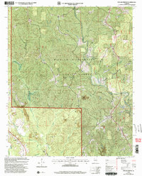
2000 Map of Poplar Springs
USGS Topo · Published 2003About this map
William B Bankhead National Forest encompasses much of this Winston County landscape, where the terrain is defined by the deep incisions of Clear Creek and its many tributaries like Otter Branch and Squaw Creek. The settlement pattern reflects a rural community rooted in small hubs and local congregations, with Ashbank and Poplar Springs serving as primary points of interest. Deeply forested areas are punctuated by numerous country churches, including Mount Ebron Ch, New Hope Ch, and Pineyucky Ch, often accompanied by family cemeteries such as the Blue Springs Cem. To the south, the landscape shifts toward industrial activity where several Strip Mines are located near Blackwater Creek. This combination of protected federal forest, scattered hilltop churches, and low-lying areas like Keiser Bottom illustrates the transition from preserved wilderness to active resource extraction at the turn of the 21st century.
Find a feature on this map
31 named features on this map. Tap any name to fly to it.
Don’t see what you’re looking for? This feature index may not catch every label — zoom into the map to look around manually.
Map Details
Editions of this 2000 Poplar Springs Map
This is the sole edition of this map. No revisions or reprints were ever made.
Other maps of this area

1893 · Jasper
USGS Topo · 1:125,000

1936 · Delmar
USGS Topo · 1:24,000

1949 · Manchester
USGS Topo · 1:24,000

1949 · Nauvoo
USGS Topo · 1:24,000

1950 · Nauvoo
USGS Topo · 1:24,000

1950 · Manchester
USGS Topo · 1:24,000

1953 · Birmingham
USGS Topo · 1:250,000

1956 · Birmingham
USGS Topo · 1:250,000

1956 · Gadsden
USGS Topo · 1:250,000

1957 · Birmingham
USGS Topo · 1:250,000