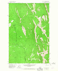
1958 Map of Porphyry Reef
USGS Topo · Published 1967About this map
The Continental Divide serves as the literal spine of this 1958 field-checked landscape, marking the boundary where Flathead National Forest meets the Lewis and Clark National Forest. This high-altitude terrain is characterized by massive geological formations including the Washboard Reef and Porphyry Reef, where steep limestone walls create a formidable natural barrier. Human presence is limited to the administrative and survival networks of the mid-century wilderness, anchored by the Wrong Creek Guard Station and a series of high mountain crossings like Sun River Pass and Teton Pass. The survey records a primitive transportation network consisting of a Pack Trail system that follows watercourses like Mc Donald Creek and Bowl Creek. This map captures a strictly protected environment, showing the intersection of three counties and a dedicated Game Preserve area centered around the headwaters of the North Fork Sun River.
Find a feature on this map
27 named features on this map. Tap any name to fly to it.
Don’t see what you’re looking for? This feature index may not catch every label — zoom into the map to look around manually.
Map Details
Editions of this 1958 Porphyry Reef Map
2 editions found
Other maps of this area

1903 · Saypo
USGS Topo · 1:125,000

1913 · Marias Pass
USGS Topo · 1:125,000

1914 · Heart Butte
USGS Topo · 1:125,000

1918 · Heart Butte
USGS Topo · 1:125,000

1936 · Silvertip
USGS Topo · 1:96,000

1942 · Silvertip
USGS Topo · 1:125,000

1955 · Choteau
USGS Topo · 1:250,000

1957 · Choteau
USGS Topo · 1:250,000

1958 · Choteau
USGS Topo · 1:250,000

1958 · Porphyry Reef
USGS Topo · 1:24,000