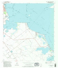
1995 Map of Port Lavaca East
USGS Topo · Published 1995About this map
Indian Point serves as a focal point for this coastal survey, where the waters of Lavaca Bay and Matagorda Bay meet. The landscape reflects a deeply historical shoreline, notably marked by the Historical Monument and Indianola Cem near the tip of Indianola Island, preserving the memory of a significant early Texas port. The inland area transitions from the residential grids of Alamo Beach and Magnolia Beach to a network of levees and coastal wetlands around Old Town Lake and Mud Lake. Industrial and maritime activity is evident in the Port Lavaca harbor facilities, including the Lynn Bayou Turning Basin and the Harbor of Refuge. This map details the intersection of the region's shipping economy, through the Matagorda Ship Channel, and its historical preservation along the shifting Gulf Coast sands.
Find a feature on this map
31 named features on this map. Tap any name to fly to it.
Don’t see what you’re looking for? This feature index may not catch every label — zoom into the map to look around manually.
Map Details
Editions of this 1995 Port Lavaca East Map
This is the sole edition of this map. No revisions or reprints were ever made.
Other maps of this area

1951 · Keller Bay
USGS Topo · 1:24,000

1952 · Port Lavaca East
USGS Topo · 1:24,000

1952 · Point Comfort
USGS Topo · 1:24,000

1952 · Olivia
USGS Topo · 1:24,000

1952 · Kamey
USGS Topo · 1:24,000

1952 · Seadrift NE
USGS Topo · 1:24,000

1952 · Seadrift
USGS Topo · 1:24,000

1952 · Port Lavaca West
USGS Topo · 1:24,000

1952 · Port O'Connor
USGS Topo · 1:24,000

1953 · Beeville
USGS Topo · 1:250,000