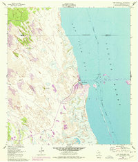
1952 Map of Port Mansfield
USGS Topo · Published 1977About this map
Port Mansfield sits at the edge of the Laguna Madre, serving as a vital coastal hub where the Port Mansfield Channel cuts through the shifting landscape to connect the mainland with the Gulf. This 1952 survey, with revisions into the mid-1970s, illustrates a dynamic environment of Shifting Sand Dunes and Sand and Mud flats. The presence of numerous named water sources across the arid coastal plain, such as Dave Dear Well, Palmital Well, and Agua Gorda Well, speaks to the importance of freshwater access for ranching and settlement in this corner of Willacy County. Navigation is a primary theme, with the Intracoastal Waterway and its associated Piling and Light markers threading through Red Fish Bay. The map also captures infrastructure like a Landing Strip and a coastal Pipeline, alongside natural features like El Sauz Island and Fourmile Slough.
Find a feature on this map
26 named features on this map. Tap any name to fly to it.
Don’t see what you’re looking for? This feature index may not catch every label — zoom into the map to look around manually.
Map Details
Editions of this 1952 Port Mansfield Map
2 editions found
Other maps of this area

1921 · Tarida Ranch
USGS Topo · 1:62,500

1951 · South of Potrero Lopeno NE
USGS Topo · 1:24,000

1952 · Green Island
USGS Topo · 1:24,000

1952 · South of Potrero Lopeno NW
USGS Topo · 1:24,000

1952 · South of Potrero Lopeno SE
USGS Topo · 1:24,000

1952 · Hawk Island
USGS Topo · 1:24,000

1952 · Port Mansfield
USGS Topo · 1:24,000

1952 · South of Potrero Lopeno
USGS Topo · 1:62,500

1953 · Brownsville
USGS Topo · 1:250,000
1955 · La Leona
USGS Topo · 1:62,500