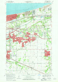
1968 Map of Portage
USGS Topo · Published 1979About this map
Industrial development and the expanding suburbs of Gary define this landscape during a period of significant growth along the Lake Michigan shoreline. The emergence of the Burns Waterway Harbor and the Portage industrial corridor contrasts with the older residential cores of East Gary and Hobart. In the south, the map documents the planned layout of South Haven and the enduring footprint of the village of Wheeler. Extensive transportation networks are visible, including the South Shore and South Bend and Penn Central railroads, which facilitated the region's heavy industry. Community life is anchored by local institutions such as Calvary Cemetery, Edison Sr High Sch, and the Seven Dolors Shrine, providing a clear view of the social and physical infrastructure of Portage as it shifted from a rural rail crossroads to a major manufacturing and residential hub.
Find a feature on this map
71 named features on this map. Tap any name to fly to it.
Don’t see what you’re looking for? This feature index may not catch every label — zoom into the map to look around manually.
Map Details
Editions of this 1968 Portage Map
4 editions found
Other maps of this area

1900 · Toleston
USGS Topo · 1:62,500

1934 · Porter
USGS Topo · 1:48,000

1940 · Porter
USGS Topo · 1:62,500

1953 · Palmer
USGS Topo · 1:24,000

1953 · Gary
USGS Topo · 1:24,000

1953 · Crown Point
USGS Topo · 1:24,000

1953 · Garyton
USGS Topo · 1:24,000

1953 · Valparaiso
USGS Topo · 1:24,000

1953 · Ogden Dunes
USGS Topo · 1:24,000

1953 · Chesterton
USGS Topo · 1:24,000