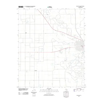
2010 Map of Post West
USGS Topo · Published 2010About this map
Close City serves as a primary reference point in this western portion of the Garza County plains, where the grid of rural roads meets the advancing development from the east. The landscape is defined by the headwaters of Sand Creek and the southern reaches of Falls Creek, illustrating the drainage patterns of the Llano Estacado. This 2010 survey documents the transition from open agricultural tracts to the structured outskirts of the regional center, highlighting the infrastructure that supports the local cotton and cattle economy. The layout of county roads, including the prominent diagonal of Highway 84, reflects decades of land use and property division in this corner of the South Plains.
Find a feature on this map
1 named feature on this map. Tap any name to fly to it.
Don’t see what you’re looking for? This feature index may not catch every label — zoom into the map to look around manually.
Map Details
Editions of this 2010 Post West Map
This is the sole edition of this map. No revisions or reprints were ever made.
Other maps of this area

1954 · Lubbock
USGS Topo · 1:250,000

1965 · Southland
USGS Topo · 1:24,000

1968 · South Dokegood Creek
USGS Topo · 1:24,000

1969 · Cap Rock SE
USGS Topo · 1:24,000

1969 · Post East
USGS Topo · 1:24,000

1969 · Grassland SE
USGS Topo · 1:24,000

1969 · Post West
USGS Topo · 1:24,000

1969 · Cooper Creek
USGS Topo · 1:24,000
1969 · Middle Creek
USGS Topo · 1:24,000

1970 · Grassland
USGS Topo · 1:24,000