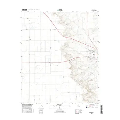
2016 Map of Post West
USGS Topo · Published 2016About this map
The Caprock Escarpment dramatically bisects this West Texas landscape, where the flat plains of the Llano Estacado drop sharply into the broken country of the Rolling Plains. The city of Post sits at the base of this transition, organized on a grid featuring W Main St and numbered avenues that reflect its planned origins. To the west, the higher plateau is characterized by large agricultural blocks and the settlement of Close City, connected by a network of county roads including Co RD 230 and Co RD 240. The rugged eastern half of the map is defined by the erosive action of seasonal waterways like Sand Cr, Rattlesnake Cr, and Falls Cr, which have carved deep canyons into the limestone and clay. This contrast between the orderly farmland above the rim and the convoluted terrain below highlights the geographic challenges that shaped local development and land use.
Find a feature on this map
32 named features on this map. Tap any name to fly to it.
Don’t see what you’re looking for? This feature index may not catch every label — zoom into the map to look around manually.
Map Details
Editions of this 2016 Post West Map
This is the sole edition of this map. No revisions or reprints were ever made.
Other maps of this area

1954 · Lubbock
USGS Topo · 1:250,000

1965 · Southland
USGS Topo · 1:24,000

1968 · South Dokegood Creek
USGS Topo · 1:24,000

1969 · Cap Rock SE
USGS Topo · 1:24,000

1969 · Post East
USGS Topo · 1:24,000

1969 · Grassland SE
USGS Topo · 1:24,000

1969 · Post West
USGS Topo · 1:24,000

1969 · Cooper Creek
USGS Topo · 1:24,000
1969 · Middle Creek
USGS Topo · 1:24,000

1970 · Grassland
USGS Topo · 1:24,000