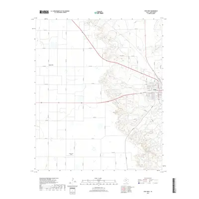
2019 Map of Post West
USGS Topo · Published 2019About this map
Post occupies the southeastern corner of this Garza County survey, where the grid of city streets meets the Caprock escarpment. The town is organized around W Main St and Ralls Rd, serving as a regional hub at the junction of major West Texas corridors. To the northwest, the small settlement of Close City lies amidst a landscape dominated by agricultural fields and ranch roads, including FM 399 and Co Rd 145. The terrain transitions sharply from the level plains in the west to the deeply dissected canyonlands in the east, carved by watercourses such as Falls Cr, Sand Cr, and Rattlesnake Cr. This topographical divide is further highlighted by Camp Post and the winding Cedar Hills Rd, which navigate the elevation changes where the Llano Estacado drops away. The map also documents aviation infrastructure at the WWD Farms Airport, reflecting the area's modern industrial and agricultural connectivity.
Find a feature on this map
47 named features on this map. Tap any name to fly to it.
Don’t see what you’re looking for? This feature index may not catch every label — zoom into the map to look around manually.
Map Details
Editions of this 2019 Post West Map
This is the sole edition of this map. No revisions or reprints were ever made.
Other maps of this area

1954 · Lubbock
USGS Topo · 1:250,000

1965 · Southland
USGS Topo · 1:24,000

1968 · South Dokegood Creek
USGS Topo · 1:24,000

1969 · Cap Rock SE
USGS Topo · 1:24,000

1969 · Post East
USGS Topo · 1:24,000

1969 · Grassland SE
USGS Topo · 1:24,000

1969 · Post West
USGS Topo · 1:24,000

1969 · Cooper Creek
USGS Topo · 1:24,000
1969 · Middle Creek
USGS Topo · 1:24,000

1970 · Grassland
USGS Topo · 1:24,000