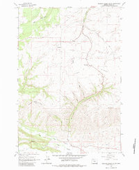
1962 Map of Postage Stamp Butte
USGS Topo · Published 1983About this map
Kingsley and the surrounding Wasco County uplands are defined by a complex network of drainages and ridges as they appeared in the early 1960s. The landscape is dominated by the massive Tygh Ridge, which peaks at Tygh Ridge Summit and drops away into deep-cut features like Butler Canyon. In the southern portion of the map, the terrain levels into the Tygh Valley, where the Tygh Valley Fairgrounds and the Highline Ditch indicate an established agricultural and community hub. Settlement patterns here are sparse but significant for genealogy, featuring the Kingsley Cem and another un-named Cem further north. This period captures the rural infrastructure of the Pacific Northwest before significant modernization, evidenced by the numerous named watercourses like Badger Creek and Tygh Creek that carve through the high plateaus and provide the lifeblood for this isolated ranching and farming country.
Find a feature on this map
21 named features on this map. Tap any name to fly to it.
Don’t see what you’re looking for? This feature index may not catch every label — zoom into the map to look around manually.
Map Details
Editions of this 1962 Postage Stamp Butte Map
3 editions found
Other maps of this area

1930 · Dufur
USGS Topo · 1:125,000

1934 · Dufur
USGS Topo · 1:125,000

1953 · The Dalles
USGS Topo · 1:250,000

1956 · The Dalles
USGS Topo · 1:250,000

1957 · The Dalles
USGS Topo · 1:250,000

1962 · Sherars Bridge
USGS Topo · 1:24,000

1962 · Wolf Run
USGS Topo · 1:24,000

1962 · Postage Stamp Butte
USGS Topo · 1:24,000

1962 · Wamic
USGS Topo · 1:24,000

1962 · Dufur East
USGS Topo · 1:24,000