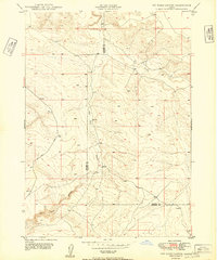
1949 Map of Pot Hole Canyon
USGS Topo · Published 1949About this map
Sailor Creek and Pot Hole Creek carve through this high desert terrain along the border of Owyhee and Elmore counties. The landscape is defined by the deep incisions of Pot Hole Canyon, a stark contrast to the surrounding plateau. Surveyed in the late 1940s using a combination of aerial photography and plane-table methods, the map captures a sparsely populated region primarily characterized by its drainage patterns and a single established Road winding through the western sections. This data, compiled just after the war, provides a precise look at the elevation and natural contours of this remote borderland before modern land management or infrastructure changes significantly altered the primitive transit routes used by ranchers and early travelers in the Idaho backcountry.
Find a feature on this map
6 named features on this map. Tap any name to fly to it.
Don’t see what you’re looking for? This feature index may not catch every label — zoom into the map to look around manually.
Map Details
Editions of this 1949 Pot Hole Canyon Map
2 editions found
Other maps of this area

1947 · Indian Cove
USGS Topo · 1:24,000

1947 · Hammett
USGS Topo · 1:24,000

1947 · Glenns Ferry
USGS Topo · 1:24,000

1948 · Hammett
USGS Topo · 1:24,000

1948 · Glenns Ferry
USGS Topo · 1:24,000

1948 · Indian Cove
USGS Topo · 1:24,000

1948 · Indian Cove
USGS Topo · 1:62,500

1948 · Glenns Ferry
USGS Topo · 1:62,500

1948 · Pence Butte
USGS Topo · 1:24,000

1948 · Grindstone Butte
USGS Topo · 1:24,000